What would the world be like if all the ice melted?

Scientific studies and simulations have shown that if humans continued to use only and exclusively fossil fuels, global warming would cause all the ice on Earth to melt, raising sea levels by more than 65 metres. This begs the question: what would the coastlines of our current continents look like if such a thing really happened?
We know that there are about twenty million (or slightly more) cubic kilometres of ice on the earth’s surface today. Almost all scientists claim that it would take at least 5,000 years to melt all this ice. However, they are also convinced that adding carbon to the atmosphere at the rate that mankind sustains today would lead to a total melting of this large quantity, raising the sea level of the entire world by 65 metres, transforming the planet into a totally ice-free place with an average temperature of about 26 °C instead of the current 14 °C.
Having said that, let us now take a close look at the maps below, which show the world as it is today but with one major difference: all the ice has melted and flowed into the sea, raising it 65 metres: the images make it easy to observe all the submerged coastal sections.
North America
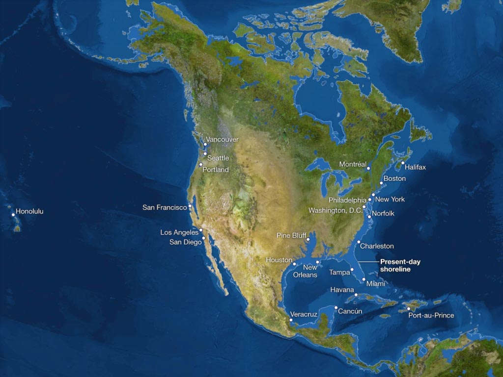
As can be seen from the image, the Atlantic coast would disappear in its entirety along with Florida and the Gulf Coast. Interestingly, California and the higher hills of San Francisco would become a group of islands while the Central Valley would turn into a giant bay. The Gulf coast of California would extend northwards and beyond the city of San Diego, which would instead disappear.
Source: National Geographic
South America
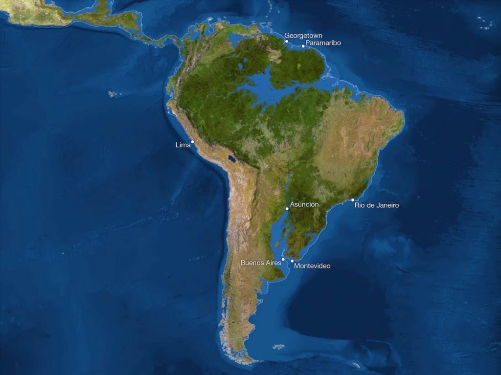
The Paraguay river basin to the south and the Amazon basin to the north would be transformed into Atlantic inlets, totally erasing Buenos Aires and the coast of Uruguay and a good “slice” of Paraguay. What would “survive” would look more like mountainous stretches along the Caribbean coast and in Central America.
Source: National Geographic
Africa
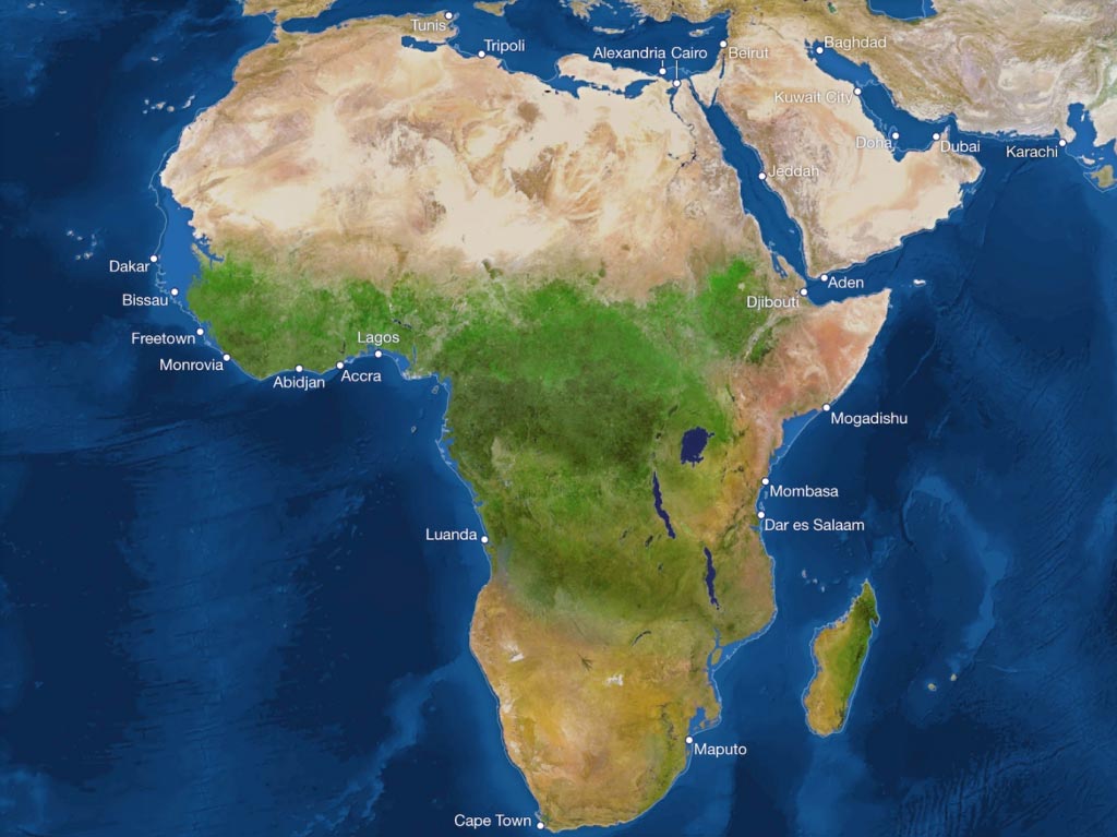
The map of the African continent is curious: comparing it with all other continents, Africa would lose the least territory. Unfortunately, however, rising temperatures would make much of Africa uninhabitable. In Egypt, the Carius and Alexandria would be submerged by the Mediterranean Sea.
Source: National Geographic
Europe
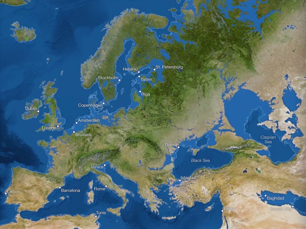
In Europe, Venice would be completely submerged by the Adriatic Sea. A little further north in Italy, on the other hand, London would truly become a postcard souvenir. In this catastrophic scenario, a few thousand years from now, the Netherlands would surely find itself totally covered by water; little or almost nothing would remain of Denmark. Instead, the Caspian and Black Seas would swell due to the expansion of the Mediterranean Sea.
Source: National Geographic
Asia
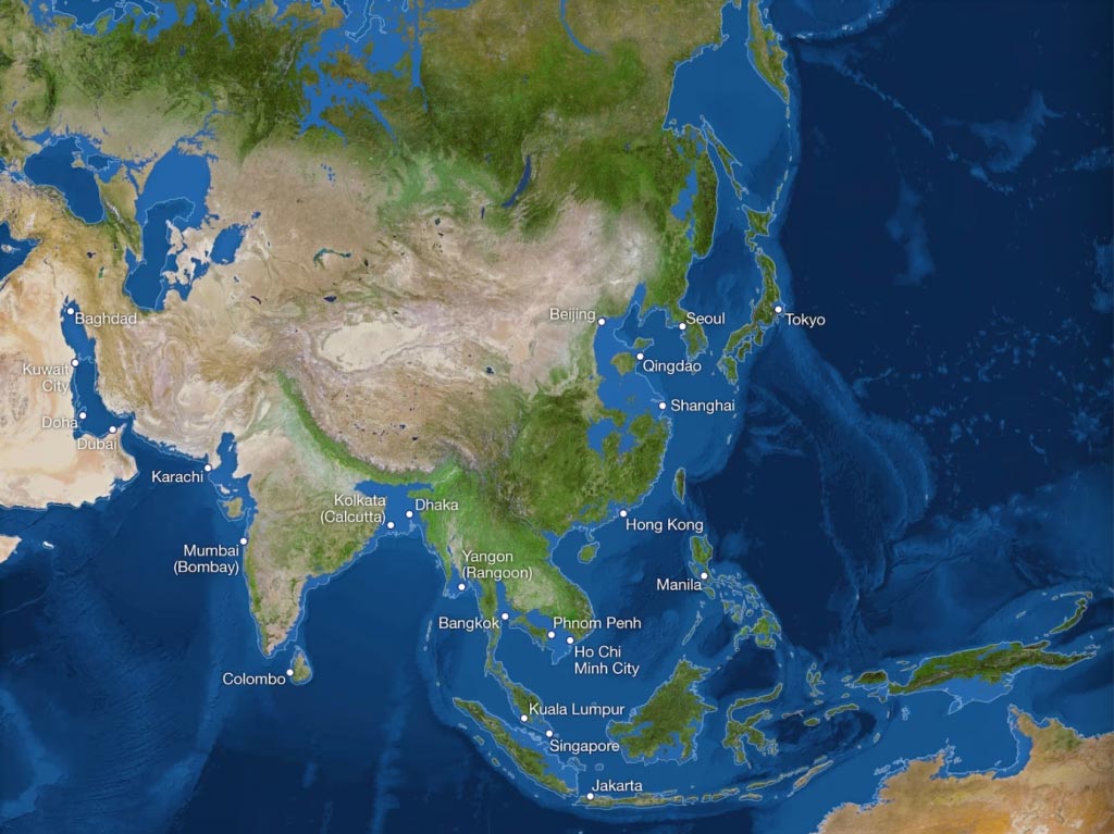
As the map shows, China would be completely inundated. Think of the inconvenience considering the number of people living there! Bangladesh would also disappear, as would much of the Indian coastline. The Cardamom Mountains of Cambodia, on the other hand, would become an island due to the flooding of the Mekong Delta.
Source: National Geographic
Australia
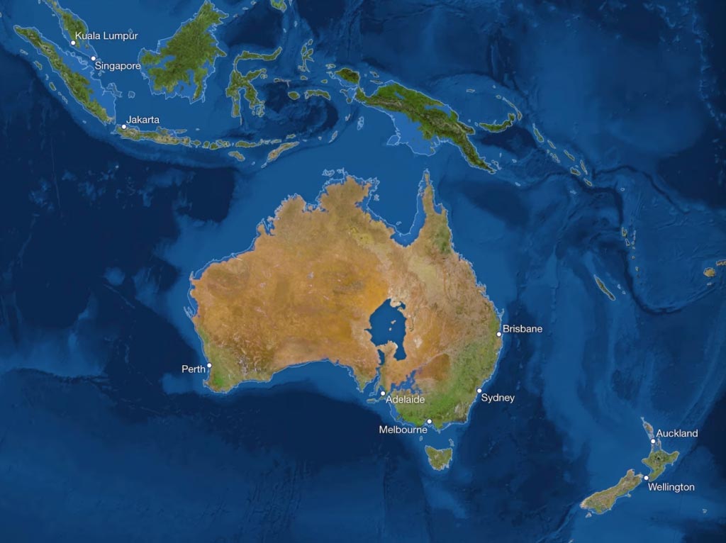
Australia, a largely desert continent, would have a gigantic lake in its interior, while a large part of the coastal zone where, today, 4 out of 5 Australians live would be lost.
Source: National Geographic
Antarctica
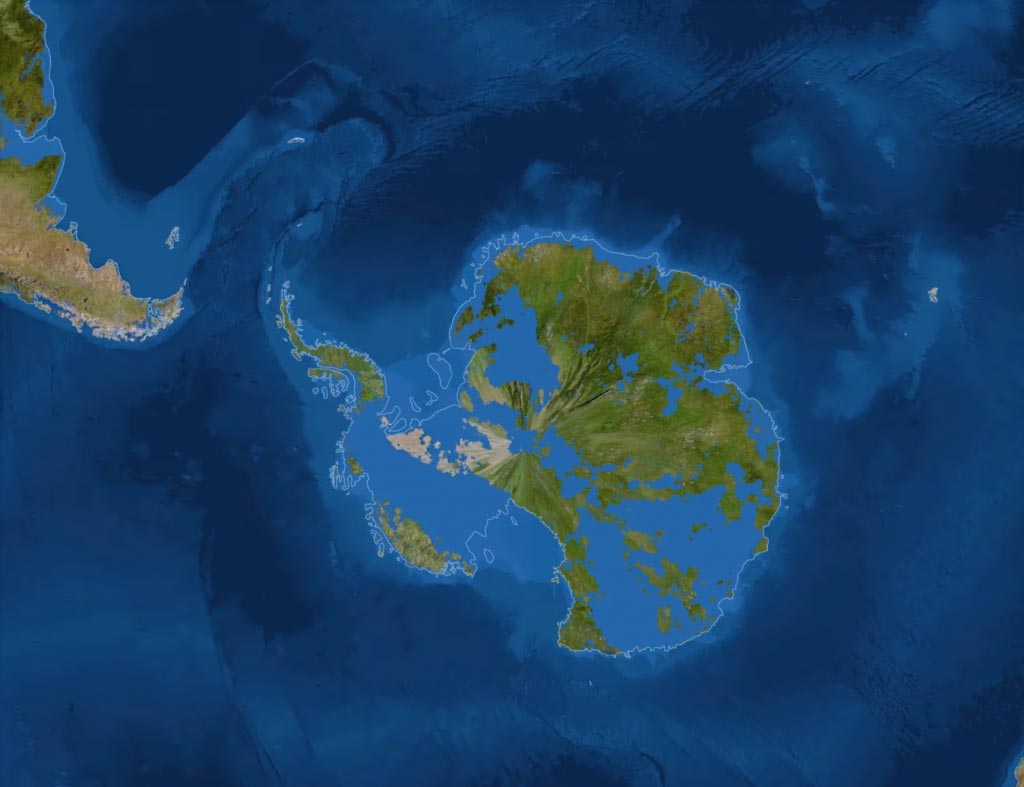
This, on the other hand, is the map of the Antarctic ice cap; the eastern one is so large that it might be strange, if not impossible, to imagine it devoid of ice (the eastern cap, in fact, contains about eighty per cent of all the ice on earth) but, at these temperatures, it is unlikely that a colossus, even of this size, could resist.
Instead, West Antarctica rests on top of a rocky sub-layer that is itself below sea level. As the ocean warms, it melts the floating ice cap from below, causing it to collapse. It should be noted that an average annual net loss of 65 million tonnes of ice has been occurring since 1992, in order to try to understand the scale!
Source: National Geographic